United Federal Britain – Local Government
This post follows on from A United Federal Britain.
Having changed all of the borders it would make sense to tidy up all of the counties. As mentioned in Legibility and Democracy, the current state of the UK’s administrative areas is a mess. Some areas are two-tier counties that have a county council as well as multiple district councils within them, while other counties are purely ceremonial and have no government function, having been split into rural and urban unitary authorities. To make matters even more confusing, some counties are two-tier, but with some districts carved out of the original ceremonial county to be unitary authorities not governed by the county council itself (e.g. Nottingham and Nottinghamshire).
In the following map, I have split each state into unitary authorities, so that there is a single consistent level of government below the state government. In a similar manner to with the states themselves, I have tried to separate urban and rural areas into separate authorities, so that local government can also avoid the pitfalls of having to cater to constituents whose requirements are too much at odds with each other.
Clearly the states themselves should have the powers to adjust their internal divisions as they see fit, rather than being handed them by the federal government, but if we are creating the states from scratch, we can at least give them sensible divisions to start with. In fact, given the issues that the US has with local government, it is apparent that managing the borders of local administrative areas cannot be permanently devolved below the level of the state. If local governments (below state level) are given some degree of control over their own borders, there needs to be a way for the state government to step in when populations change too much or their existing layouts become pathological. A similar kind of approach to the proposal for adjusting states within a federation may work for this.
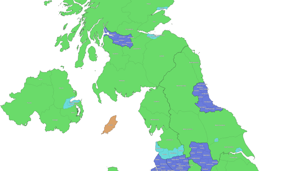
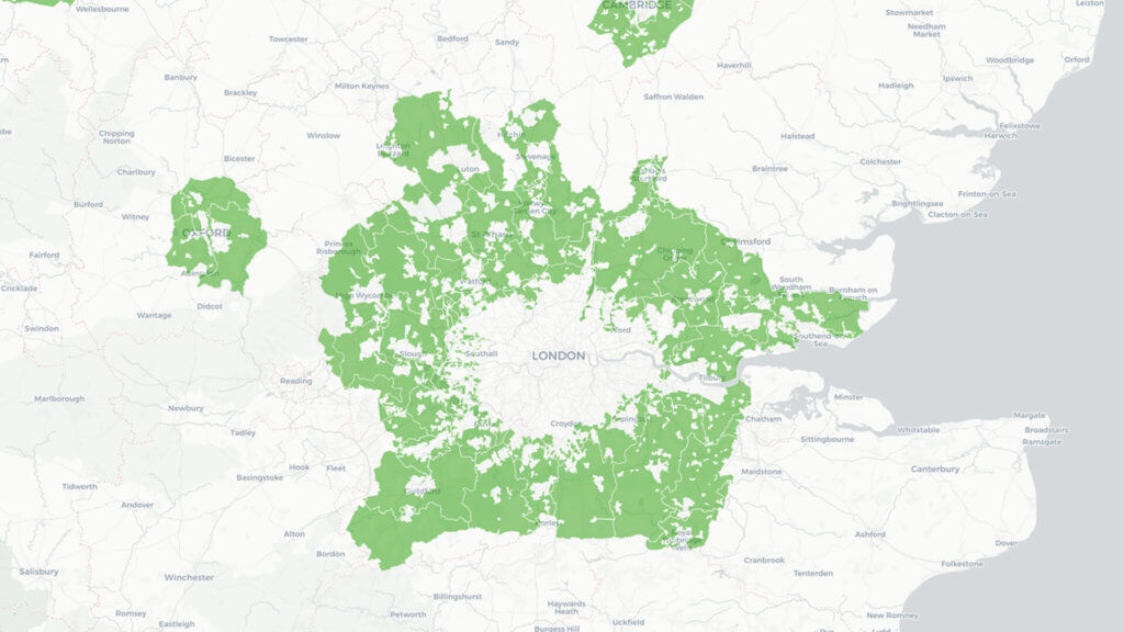
These administrative divisions are referred to as “cities” for urban areas of rural states (coloured cyan), “counties” for rural areas of rural states (coloured green) and “boroughs” for areas of metropolitan states (coloured blue):
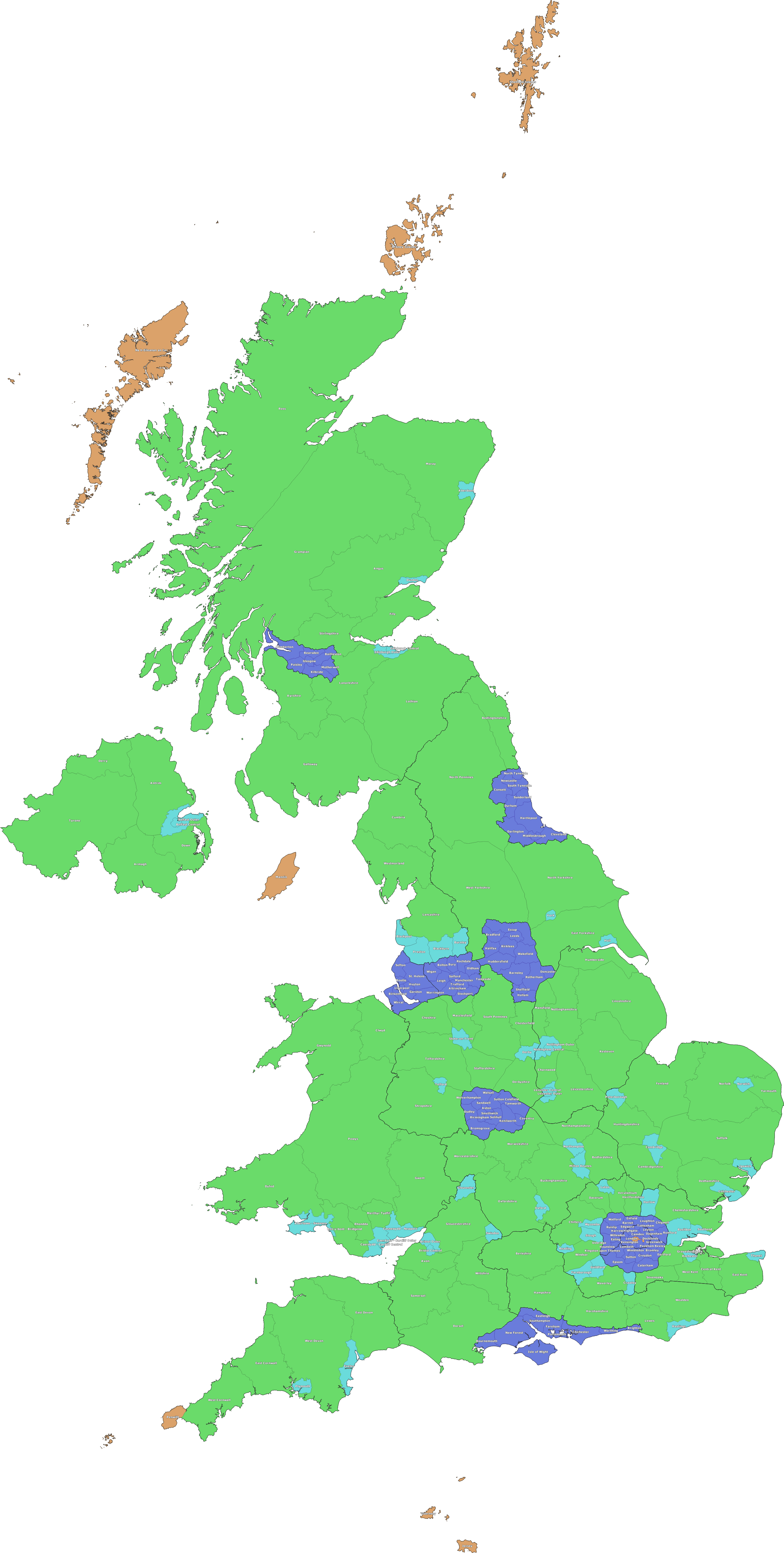
These 256 divisions consist of 85 Counties, 50 Cities, 109 Boroughs and 12 special districts. Aside from the special districts that I will mention briefly below, all 244 counties, cities and boroughs have a population between 125,000 and 400,000. Population information can be seen on the map below by clicking the relevant area.
This is in stark contrast with the current situation in which there are 404 principal local authorities in the UK – 25 county councils, 188 district councils, 56 unitary authorities, 36 metropolitan boroughs, 32 London boroughs, 32 council areas in Scotland, 22 principal areas in Wales and 11 local government districts in Northern Ireland, as well as the sui generis Council of the Isles of Scilly and the City of London Corporation. The unitary authorities alone vary in size from Cornwall with 570,000 people to Rutland with 40,000, whilst the largest metropolitan borough is Birmingham with 1,100,000 people and the Isles of Scilly have a population of just over 2,000.
Brief side-note on “Special Districts”:
- The special districts are smaller in population (21,000 to 100,000) and are coloured orange on the map.
- They consist of central London (London, Westminster, Bloomsbury, Southwark, Docklands), Northern Scotland (Orkney, Shetland and the Outer Hebrides), Penwith (including the Isles of Scilly), Jersey, Guernsey and the Isle of Mann.
- These 12 exceptions are due to their unique nature, for which it is probably beneficial for them to have their own local governments despite their small size.
- The 3 sets of Scottish islands each need their own local councils due to how far they are away from each other, despite their small populations.
- Penwith includes the unique Isles of Scilly whose requirements could be overlooked if it were combined into an area that dwarfed them too much. On their own, the Isles of Scilly make up around 0.1% of the population of Kernow, so keeping them as a district by themselves would both involve the Kernow state government having to deal with a tiny authority which would be quite inefficient, as well as having the local authority itself being comparatively large with respect to the population it serves. This district is then aimed at finding a middle ground between being so large that the Isles unusual requirements are overlooked, and so small that the authority becomes a burden on both the citizens and the state government.
- Central London’s 5 special districts have been kept small because of the sheer number of companies registered there. Just as addressing people’s concerns becomes more difficult as the number of people increases, the same is true of companies. This also avoids a single local authority having too much influence over the large economy of central London.
- The crown dependencies of Jersey, Guernsey and the Isle of Mann are exceptions because they currently have independent governments, and any attempt to combine them properly into a United Federal Britain would likely require an element of independent government to continue.
- I have placed the Isle of Mann into Rheged and the channel islands into Solent because they are all far too small to be states in their own right, but if their integration could be achieved, they would likely retain more autonomy within their respective states than an ordinary district.
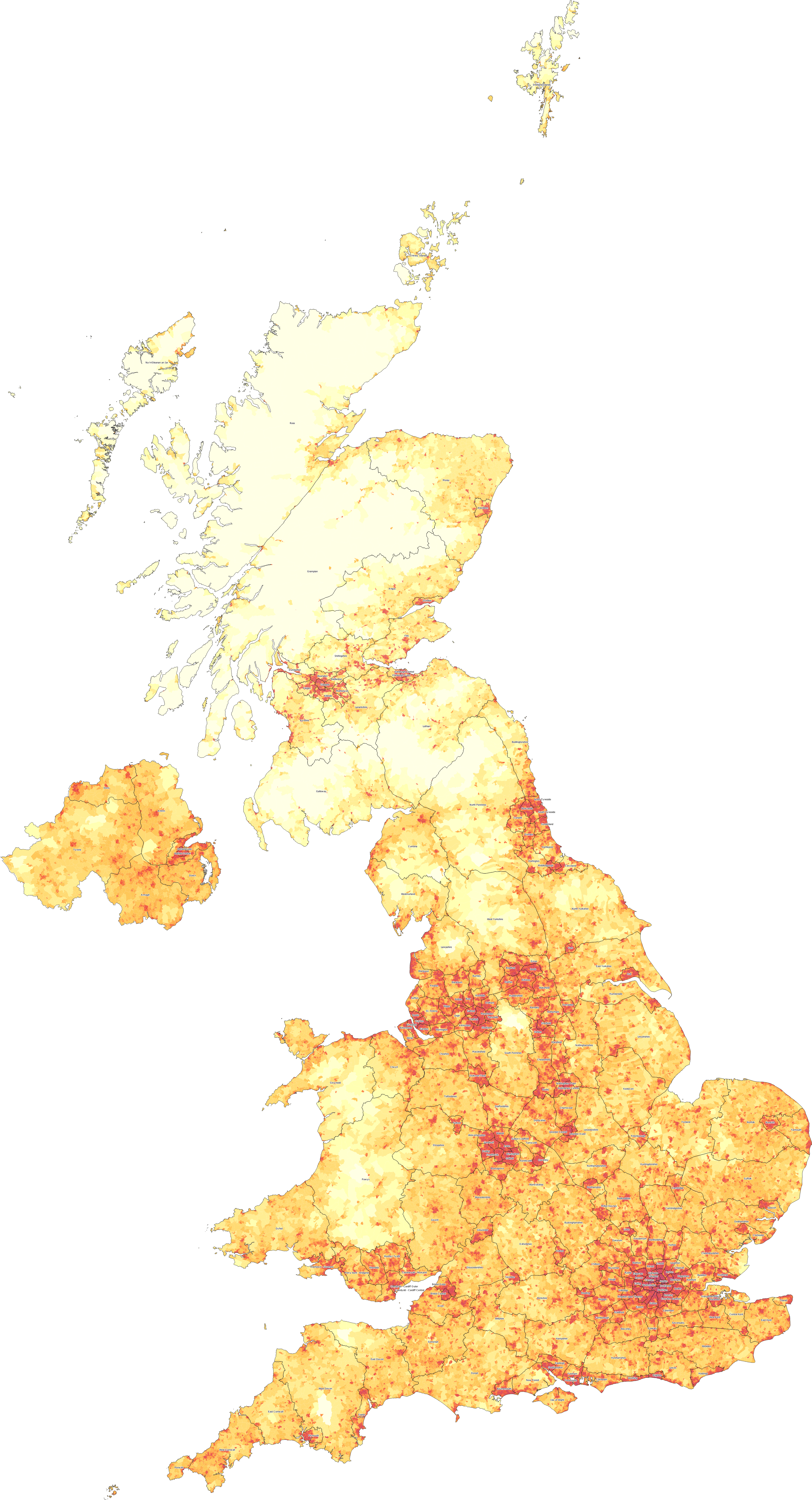
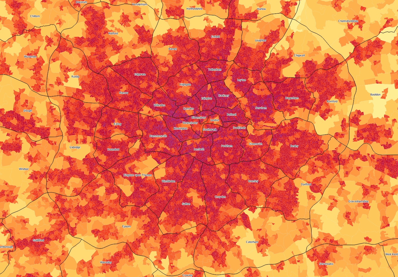
With these administrative divisions (listed in full at the bottom), it might look like I have used a cut-off of 750 people per square kilometre between something being a county and being a city. It is not just an arbitrary cut-off though. The least dense cities (Blackburn, Cambridge and Newport) still have city-like characters, with a main centre, some satellite towns and some less dense suburbs or countryside around them. This is in contrast to the most dense counties (Windsor and Hertfordshire) which have a much more even distribution of towns, giving a more decentralised character. With this approach in mind, I have tried to adjust the borders of the cities and counties to generate a sensible structure with cities and counties having both different characters and being on different sides of a population density cut-off.
I have uploaded the map above to Google Maps, allowing it to be overlaid on top of a zoomable map of the UK:
Cities and Counties
The UK currently does not have a population based metric for determining whether something is a city, preferring instead to confer city status by virtue of having a cathedral, or manually on an ad-hoc basis. Accordingly, there are several tiny cities on this list that no longer make the cut (e.g. Truro, Bangor and Ely), and several cities that I outline that were not on the list (e.g. Telford, Luton and Milton Keynes). It is important to note however that some of the “official cities” on the list linked above have extremely generous borders, that include a large amount of countryside. The actual urban areas of Chelmsford, Canterbury and Lancaster are much smaller than their officially designated city limits, so they have a significantly lower population. This means that it makes sense to combine them with their surrounding area to make a sensible sized administrative area, but that this would be a county rather than a city.
In fact, a much better sign of whether a settlement is worthy of being considered a city is actually whether it has been split from its county, as a unitary authority. All of the urban unitary authorities that currently exist in England have made it as cities under this plan – Blackburn, Blackpool, Bristol, Derby, Hull, Leicester, Luton, Medway (as Rochester), Milton Keynes, Nottinham, Oxford, Peterborough, Plymouth, Reading, Slough, Southend, Stoke, Swindon, Telford, Thurrock (as Basildon), Torquay (as Exeter) and York.
Aside from these, the plan designates other cities in England that weren’t already unitary authorities – Burnley, Cambridge, Colchester (inc. Clacton), Crawley, Farnborough (inc. Aldershot), Gloucester (inc. Cheltenham), Guildford (inc. Woking), Harlow (inc. Bishop’s Stortford), Hastings (inc. Eastbourne), Ipswich (inc. Felixtowe), Northampton, Norwich, Preston (inc. Chorley), Thanet (consisting of Margate and Ramsgate) and Wycombe (inc. Beaconsfield). Many of the cities in this list are polycentric, having more than one fairly densely populated city centre, but they have a sufficiently high population of sufficiently high density to be qualitatively different to their surrounding counties.
The differences between cities and counties are apparent when the borders are overlaid on a map of population density, similar to the one in the Final Proposal section of the previous post (this one is worth clicking on, to zoom in and see the detail):
London
Surrounding London (in the states of Surrey and Essex) are several of these cities, sometimes forming corridors around major routes into London. These are Luton, Wycombe, Slough, Reading, Farnborough, Guildford and Crawley in Surrey and Harlow, Basildon, Southend, Rochester and Thanet in Essex. If the states have adequate autonomy over urban development and planning, these cities could be permitted to expand within their borders. This would allow for London to grow within key access corridors, without giving way to uncontrolled urban sprawl.
These corridors around established population centres allow for the possibility of a “Green Wedge” approach to London’s growing suburbs, rather than the current far more restrictive greenbelt. The greenbelt was originally instituted to protect natural spaces around cities, but is so restrictive that it now has a stifling effect on London and the many other cities it affects, attempting to freeze the growth of a city at a particular arbitrary point in time. By encouraging growth exclusively within these corridors, green space remains accessible and urban sprawl is curtailed, but people are still able to live near to where their skills are in demand.
One further thing to note about the cities in this proposal is the presence of some cities that have an “outer district”. These are Bristol, Leicester, Edinburgh, Nottingham, Cardiff and Belfast. Whilst still too small to be metropolitan states, these cities are too large to be contained within a single administrative division. Combining the suburbs of a large city with the rural area surrounding it would again cause friction between the different needs of these two groups of people, so I carved out 6 “cities” that allow these populous suburbs and satellite towns to have their own local government.
An alternative to this would have been to simply take the large city in its entirety, then split it down the middle, giving a North and a South (or East and West) of each city. I decided against this, because as with London’s central and more peripheral areas, the high population density at the centre of a city has unique requirements that are likely best served by having their own administration. To split large cities down the middle would deny the opportunity for centre and suburbs to each benefit from a more aligned government.
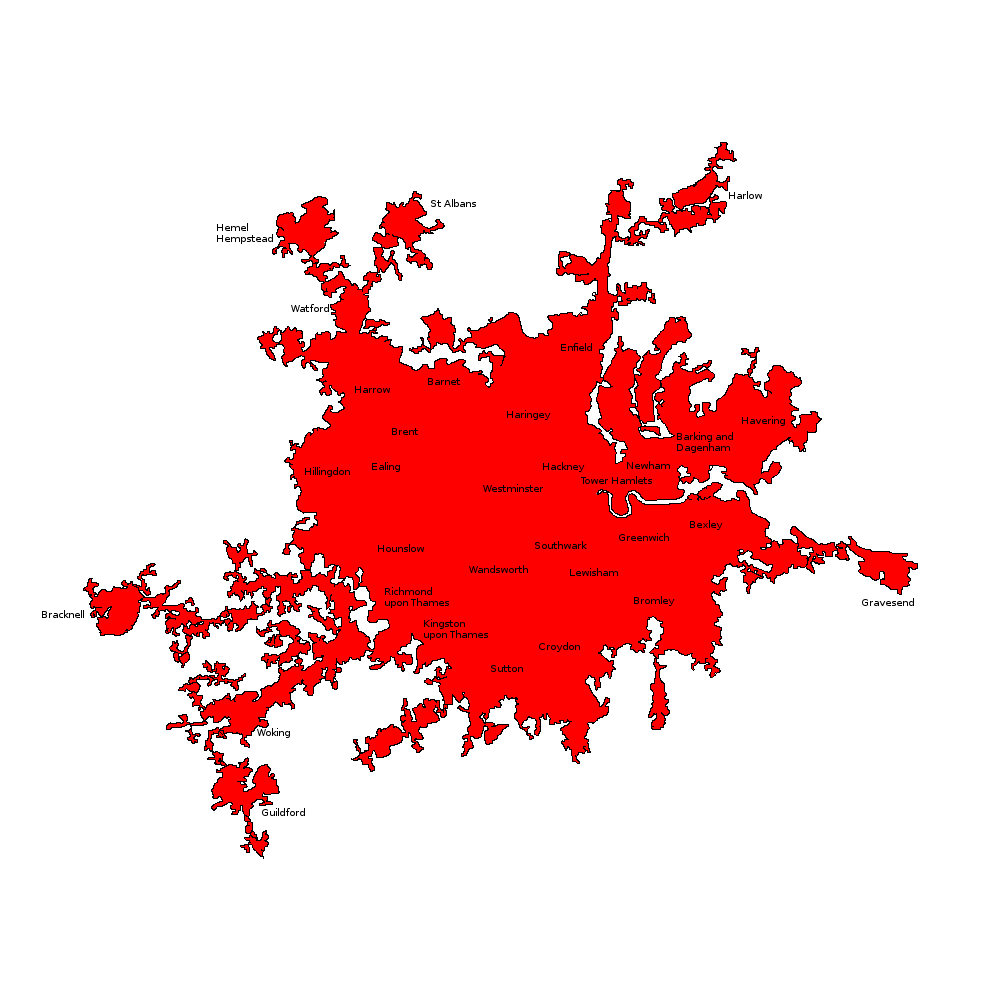
As an extreme example of this density discrepancy, I present to you a version of the population density map above, zoomed in on London. Even though Middlesex and Croydon have population densities higher than any of the other states outside London (2,911 and 2,821 people per square km respectively), the state of London itself has a population density over 3 times as high, at 9,115 people per square km:
Looking at the cities outside of the metropolitan states, it is clear that the 6 cities with central and outer divisions are similar to this. The central “cities” are by far the most densely populated, ranging from 4,009 to 5,553 people per square km. This is more than double the density of their respective outer cities, and most other cities under this plan.
Borders
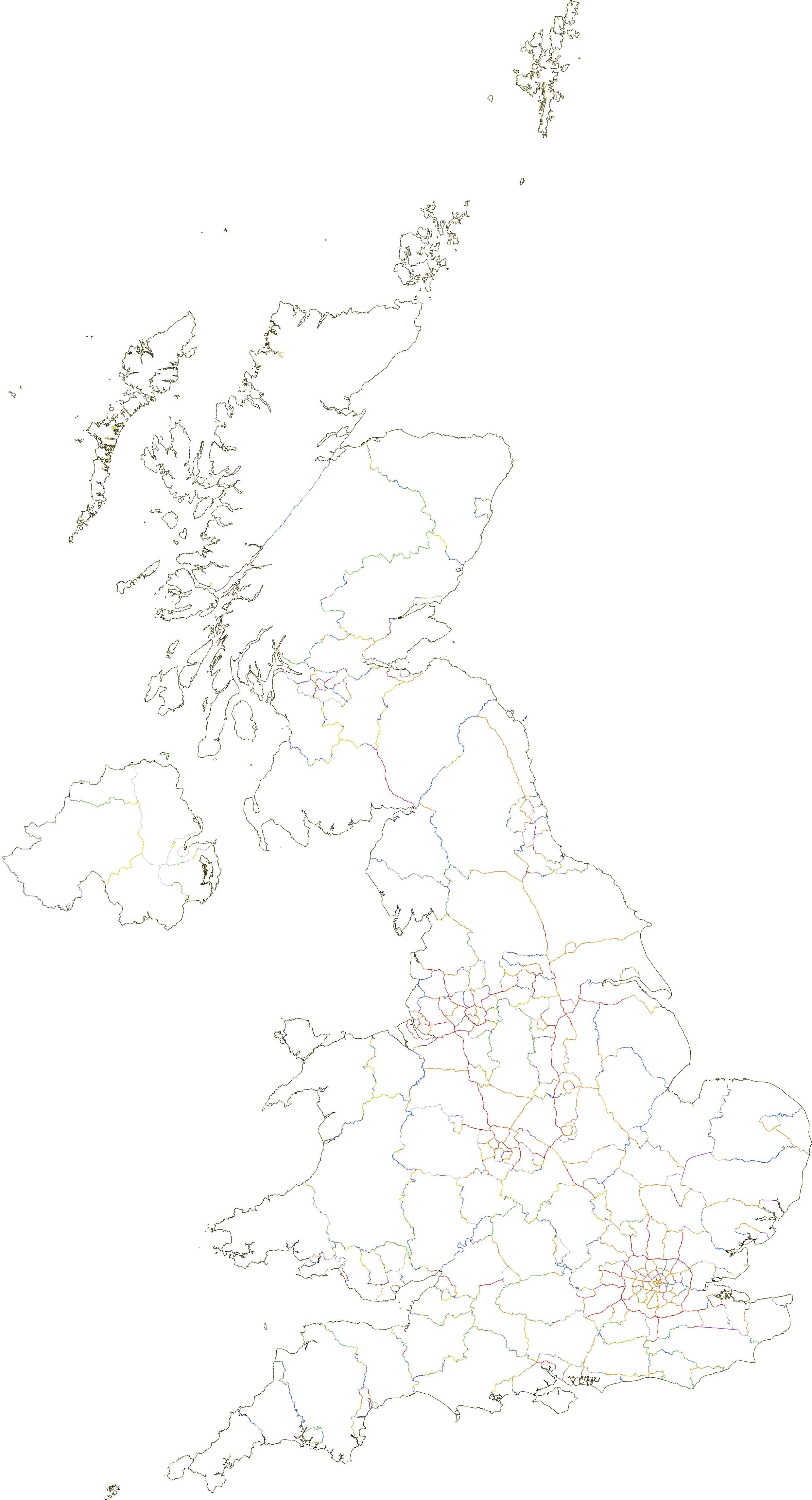
Because I mainly based these borders on geographical features, I was able to produce a map that shows which feature was used to make the border. In the map below, motorways are shown as red, A-roads as orange, railways as purple, rivers as blue, national park/AONB borders as green, existing county borders as yellow, existing district borders as dark grey and other smaller features as light grey:
Full List of Divisions
Just in case anyone wants it, below is the full list of all 256 divisions, along with the the key statistics of each. The final two columns are a possible two-letter state code and single-letter district code that provide each district with a unique identifier. (The two-letter state codes have also been chosen to avoid any clashes with US two-letter state codes, to avoid confusion between for example; Elgin, SC and Elgin, SL or Manchester, NH and Manchester MH).
These could ultimately be used to supersede postcodes, finally aligning the postal address system with the administrative geography of the country. This would avoid confusing situations such as Barking having the postcode area IG (Ilford) rather than E (East London), or Aberystwyth having the postcode area SY (Shrewsbury) rather than a Welsh postcode area.
| Name | Type | Area | State | Pop. | Density | GVA (£m) | GVA/ capita | State Code | Dist. Code |
|---|---|---|---|---|---|---|---|---|---|
| Norwich | City | 137 | Anglia | 217865 | 1592 | 5515 | 25315 | AN | W |
| Ipswich | City | 165 | Anglia | 199485 | 1212 | 4885 | 24490 | AN | I |
| Peterborough | City | 166 | Anglia | 178265 | 1074 | 4920 | 27597 | AN | P |
| Colchester | City | 207 | Anglia | 207988 | 1006 | 3980 | 19135 | AN | L |
| Cambridge | City | 252 | Anglia | 193216 | 767 | 7543 | 39042 | AN | C |
| Yarmouth | County | 621 | Anglia | 214599 | 346 | 4184 | 19499 | AN | Y |
| Dedhamshire | County | 1572 | Anglia | 338569 | 215 | 6696 | 19777 | AN | D |
| Huntingdonshire | County | 1219 | Anglia | 195689 | 161 | 4877 | 24922 | AN | H |
| Cambridgeshire | County | 1430 | Anglia | 215302 | 151 | 5629 | 26146 | AN | B |
| Fenland | County | 2840 | Anglia | 326365 | 115 | 6685 | 20484 | AN | F |
| Suffolk | County | 3450 | Anglia | 379935 | 110 | 8601 | 22639 | AN | S |
| Norfolk | County | 3353 | Anglia | 367426 | 110 | 7170 | 19515 | AN | N |
| Birmingham | Borough | 43 | Bromwich | 234943 | 5447 | 5241 | 22307 | BR | B |
| Aston | Borough | 42 | Bromwich | 186616 | 4428 | 4091 | 21921 | BR | A |
| Smethwick | Borough | 67 | Bromwich | 279293 | 4141 | 5879 | 21051 | BR | M |
| Coventry | Borough | 71 | Bromwich | 267595 | 3756 | 5905 | 22066 | BR | C |
| Sandwell | Borough | 55 | Bromwich | 178086 | 3252 | 3211 | 18030 | BR | L |
| Solihull | Borough | 115 | Bromwich | 357943 | 3107 | 9525 | 26611 | BR | H |
| Dudley | Borough | 126 | Bromwich | 366513 | 2914 | 5930 | 16180 | BR | D |
| Wolverhampton | Borough | 119 | Bromwich | 322856 | 2708 | 5719 | 17715 | BR | V |
| Sutton Coldfield | Borough | 122 | Bromwich | 224526 | 1842 | 5063 | 22550 | BR | S |
| Walsall | Borough | 144 | Bromwich | 236785 | 1647 | 4073 | 17201 | BR | W |
| Bromsgrove | Borough | 272 | Bromwich | 244230 | 897 | 5219 | 21370 | BR | G |
| Tamworth | Borough | 291 | Bromwich | 247404 | 850 | 4876 | 19710 | BR | T |
| Kenilworth | Borough | 277 | Bromwich | 125759 | 454 | 3569 | 28377 | BR | K |
| Wimbledon | Borough | 48 | Croydon | 276903 | 5762 | 7504 | 27101 | CR | W |
| Croydon | Borough | 65 | Croydon | 367036 | 5640 | 8369 | 22801 | CR | Y |
| Sutton | Borough | 75 | Croydon | 389271 | 5210 | 9577 | 24603 | CR | S |
| Bromley | Borough | 61 | Croydon | 272140 | 4443 | 5354 | 19675 | CR | B |
| Bexley | Borough | 83 | Croydon | 361924 | 4348 | 7081 | 19566 | CR | X |
| Kingston upon Thames | Borough | 76 | Croydon | 290024 | 3792 | 8967 | 30919 | CR | K |
| Dartford | Borough | 102 | Croydon | 185414 | 1815 | 4561 | 24601 | CR | D |
| Epsom | Borough | 234 | Croydon | 343815 | 1471 | 11041 | 32114 | CR | E |
| Caterham | Borough | 187 | Croydon | 141945 | 759 | 3130 | 22054 | CR | C |
| Caerdydd – Cardiff Central | City | 30 | Cymru | 137548 | 4531 | 3472 | 25243 | CY | C |
| Caerdydd – Cardiff Outer | City | 284 | Cymru | 351628 | 1238 | 7338 | 20869 | CY | O |
| Abertawe – Swansea | City | 409 | Cymru | 366113 | 896 | 6350 | 17346 | CY | A |
| Casnewydd – Newport | City | 323 | Cymru | 255300 | 790 | 4870 | 19074 | CY | N |
| Rhondda | County | 396 | Cymru | 239422 | 605 | 3771 | 15751 | CY | R |
| Merthyr Tydfil | County | 434 | Cymru | 256662 | 591 | 3429 | 13359 | CY | M |
| Pen-y-bont – Bridgend | County | 841 | Cymru | 225250 | 268 | 4053 | 17995 | CY | B |
| Clwyd | County | 1706 | Cymru | 393020 | 230 | 7899 | 20099 | CY | L |
| Gwent | County | 3325 | Cymru | 327665 | 99 | 6465 | 19731 | CY | G |
| Dyfed | County | 3842 | Cymru | 273827 | 71 | 4305 | 15721 | CY | D |
| Gwynedd | County | 4407 | Cymru | 306853 | 70 | 5027 | 16383 | CY | W |
| Powys | County | 7361 | Cymru | 205649 | 28 | 3493 | 16984 | CY | P |
| Hull | City | 107 | Deira | 311878 | 2917 | 6064 | 19445 | DR | H |
| York | City | 62 | Deira | 152893 | 2447 | 3746 | 24499 | DR | Y |
| Bedlingtonshire | County | 1345 | Deira | 218771 | 163 | 3490 | 15951 | DR | B |
| East Yorkshire | County | 2756 | Deira | 361392 | 131 | 6841 | 18930 | DR | E |
| North Yorkshire | County | 4490 | Deira | 364479 | 81 | 7811 | 21430 | DR | N |
| West Yorkshire | County | 4726 | Deira | 359798 | 76 | 8152 | 22658 | DR | W |
| North Pennines | County | 7041 | Deira | 196477 | 28 | 3341 | 17002 | DR | P |
| Leeds | Borough | 99 | Elmet | 347041 | 3509 | 9532 | 27466 | EM | L |
| Sheffield | Borough | 53 | Elmet | 179924 | 3376 | 3565 | 19815 | EM | S |
| Bradford | Borough | 146 | Elmet | 385450 | 2642 | 6984 | 18118 | EM | B |
| Kirklees | Borough | 184 | Elmet | 372908 | 2025 | 7971 | 21375 | EM | K |
| Hallam | Borough | 186 | Elmet | 359168 | 1933 | 7003 | 19499 | EM | H |
| Doncaster | Borough | 100 | Elmet | 150462 | 1509 | 2541 | 16889 | EM | D |
| Halifax | Borough | 135 | Elmet | 189022 | 1401 | 3873 | 20489 | EM | X |
| Wakefield | Borough | 289 | Elmet | 282779 | 978 | 5844 | 20665 | EM | W |
| Rotherham | Borough | 289 | Elmet | 275502 | 952 | 4641 | 16847 | EM | R |
| Huddersfield | Borough | 316 | Elmet | 259107 | 819 | 4327 | 16701 | EM | U |
| Barnsley | Borough | 313 | Elmet | 248511 | 793 | 3851 | 15495 | EM | Y |
| Eccup | Borough | 386 | Elmet | 256502 | 665 | 6380 | 24873 | EM | E |
| Rochester | City | 75 | Essex | 242318 | 3225 | 4255 | 17560 | EX | R |
| Southend | City | 123 | Essex | 305528 | 2485 | 5055 | 16544 | EX | S |
| Thanet | City | 104 | Essex | 134186 | 1287 | 2016 | 15021 | EX | T |
| Basildon | City | 362 | Essex | 375409 | 1037 | 8806 | 23457 | EX | B |
| Harlow | City | 301 | Essex | 269563 | 896 | 6429 | 23851 | EX | H |
| Graveshamshire | County | 428 | Essex | 220980 | 516 | 4594 | 20787 | EX | G |
| West Kent | County | 391 | Essex | 187593 | 480 | 4540 | 24204 | EX | W |
| Central Kent | County | 517 | Essex | 216113 | 418 | 4450 | 20589 | EX | K |
| Sevenoaks | County | 464 | Essex | 181090 | 390 | 4777 | 26379 | EX | O |
| East Kent | County | 991 | Essex | 364635 | 368 | 6628 | 18177 | EX | E |
| Chelmsfordshire | County | 1149 | Essex | 309066 | 269 | 7358 | 23807 | EX | C |
| Glasgow | Borough | 52 | Glesga | 264396 | 5125 | 8391 | 31738 | GL | G |
| Motherwell | Borough | 129 | Glesga | 225267 | 1752 | 4280 | 18999 | GL | M |
| Bearsden | Borough | 130 | Glesga | 217175 | 1677 | 5166 | 23789 | GL | B |
| Kilbride | Borough | 198 | Glesga | 327866 | 1658 | 6431 | 19613 | GL | K |
| Paisley | Borough | 151 | Glesga | 225641 | 1496 | 5467 | 24230 | GL | P |
| Baillieston | Borough | 146 | Glesga | 192395 | 1314 | 5104 | 26529 | GL | L |
| Dumbarton | Borough | 359 | Glesga | 200490 | 559 | 3818 | 19041 | GL | D |
| Oxford | City | 157 | Hwicce | 224481 | 1431 | 8513 | 37921 | HC | O |
| Northampton | City | 170 | Hwicce | 223254 | 1311 | 5832 | 26122 | HC | N |
| Milton Keynes | City | 231 | Hwicce | 244233 | 1059 | 10156 | 41582 | HC | M |
| Northamptonshire | County | 880 | Hwicce | 271717 | 309 | 5800 | 21346 | HC | H |
| Bedfordshire | County | 1109 | Hwicce | 330429 | 298 | 6972 | 21099 | HC | B |
| Worcestershire | County | 1308 | Hwicce | 295883 | 226 | 6522 | 22041 | HC | C |
| Warwickshire | County | 1607 | Hwicce | 359766 | 224 | 10503 | 29193 | HC | W |
| Buckinghamshire | County | 2175 | Hwicce | 320725 | 147 | 8592 | 26789 | HC | K |
| Oxfordshire | County | 2256 | Hwicce | 269493 | 119 | 7765 | 28814 | HC | X |
| Plymouth | City | 159 | Kernow | 263269 | 1661 | 5222 | 19833 | KW | P |
| Exeter | City | 353 | Kernow | 373219 | 1058 | 8033 | 21524 | KW | X |
| West Cornwall | County | 1624 | Kernow | 327788 | 202 | 5877 | 17928 | KW | W |
| Penwith | Special | 247 | Kernow | 48586 | 197 | 890 | 18321 | KW | H |
| East Devon | County | 2546 | Kernow | 283100 | 111 | 5466 | 19309 | KW | E |
| East Cornwall | County | 1724 | Kernow | 157759 | 92 | 2828 | 17928 | KW | C |
| West Devon | County | 4813 | Kernow | 350688 | 73 | 6619 | 18874 | KW | D |
| Leicester Central | City | 59 | Lindsey | 277327 | 4662 | 6205 | 22375 | LY | L |
| Nottingham Central | City | 61 | Lindsey | 243013 | 4009 | 5678 | 23365 | LY | N |
| Leicester Outer | City | 104 | Lindsey | 216107 | 2069 | 4494 | 20796 | LY | U |
| Nottingham Outer | City | 210 | Lindsey | 368290 | 1756 | 7816 | 21223 | LY | O |
| Mansfield | County | 545 | Lindsey | 345159 | 634 | 5945 | 17225 | LY | M |
| Charnwood | County | 442 | Lindsey | 173687 | 393 | 3284 | 18905 | LY | C |
| Humberside | County | 858 | Lindsey | 330759 | 386 | 6595 | 19938 | LY | H |
| Nottinghamshire | County | 1539 | Lindsey | 251348 | 163 | 4622 | 18390 | LY | T |
| Kesteven | County | 2361 | Lindsey | 323160 | 137 | 6233 | 19288 | LY | K |
| Lincolnshire | County | 3381 | Lindsey | 376382 | 111 | 7011 | 18629 | LY | I |
| Leicestershire | County | 1931 | Lindsey | 208307 | 108 | 4781 | 22953 | LY | E |
| Bethnal | Borough | 14 | London | 213987 | 14781 | 12932 | 60434 | LD | B |
| Islington | Borough | 13 | London | 168212 | 13105 | 11800 | 70147 | LD | I |
| Hackney | Borough | 17 | London | 226015 | 13074 | 6340 | 28051 | LD | A |
| Camden | Borough | 13 | London | 160976 | 12387 | 25812 | 160345 | LD | C |
| Bloomsbury | Special | 5 | London | 54853 | 11991 | 6458 | 117735 | LD | U |
| Kensington | Borough | 19 | London | 221748 | 11873 | 27037 | 121926 | LD | K |
| Lambeth | Borough | 22 | London | 258331 | 11776 | 8906 | 34473 | LD | L |
| Southwark | Special | 6 | London | 57502 | 9682 | 2497 | 43424 | LD | S |
| Peckham | Borough | 36 | London | 345282 | 9667 | 13056 | 37813 | LD | P |
| Tottenham | Borough | 20 | London | 186317 | 9487 | 3916 | 21020 | LD | T |
| Docklands | Special | 7 | London | 64223 | 9023 | 12372 | 192647 | LD | O |
| Willesden | Borough | 23 | London | 199696 | 8777 | 10649 | 53325 | LD | D |
| Hammersmith | Borough | 41 | London | 346834 | 8472 | 15608 | 45001 | LD | M |
| Newham | Borough | 47 | London | 351533 | 7545 | 6772 | 19265 | LD | E |
| Westminster | Special | 7 | London | 50769 | 7109 | 10821 | 213142 | LD | W |
| Leyton | Borough | 27 | London | 184671 | 6786 | 3121 | 16899 | LD | Y |
| Highgate | Borough | 38 | London | 254853 | 6768 | 13904 | 54556 | LD | H |
| Greenwich | Borough | 28 | London | 151729 | 5505 | 2543 | 16757 | LD | G |
| London | Special | 5 | London | 20160 | 4146 | 39902 | 1979289 | LD | N |
| Trafford | Borough | 52 | Manchester | 220060 | 4268 | 7094 | 32236 | MH | T |
| Manchester | Borough | 90 | Manchester | 371041 | 4134 | 10225 | 27558 | MH | M |
| Salford | Borough | 59 | Manchester | 208880 | 3560 | 4806 | 23007 | MH | S |
| Bolton | Borough | 102 | Manchester | 207329 | 2042 | 3489 | 16830 | MH | B |
| Tameside | Borough | 116 | Manchester | 215641 | 1861 | 3404 | 15786 | MH | D |
| Bury | Borough | 100 | Manchester | 184154 | 1834 | 3080 | 16726 | MH | Y |
| Altrincham | Borough | 121 | Manchester | 219917 | 1813 | 7145 | 32488 | MH | A |
| Stockport | Borough | 166 | Manchester | 291233 | 1751 | 7023 | 24115 | MH | P |
| Oldham | Borough | 123 | Manchester | 207542 | 1683 | 3210 | 15469 | MH | O |
| Wigan | Borough | 161 | Manchester | 265236 | 1648 | 4015 | 15136 | MH | W |
| Rochdale | Borough | 157 | Manchester | 218511 | 1391 | 3439 | 15738 | MH | R |
| Leigh | Borough | 153 | Manchester | 163853 | 1074 | 3453 | 21071 | MH | L |
| Stoke-on-Trent | City | 198 | Mercia | 375256 | 1891 | 6852 | 18259 | MR | S |
| Derby | City | 184 | Mercia | 320764 | 1743 | 7943 | 24762 | MR | D |
| Telford | City | 104 | Mercia | 144029 | 1383 | 3057 | 21226 | MR | T |
| Chesterfield | County | 587 | Mercia | 384851 | 656 | 7304 | 18978 | MR | H |
| Staffordshire | County | 889 | Mercia | 362214 | 408 | 6906 | 19067 | MR | F |
| Cheshire | County | 931 | Mercia | 356699 | 383 | 10229 | 28677 | MR | C |
| Derbyshire | County | 996 | Mercia | 346906 | 348 | 7996 | 23050 | MR | Y |
| Macclesfield | County | 660 | Mercia | 222796 | 338 | 6159 | 27644 | MR | M |
| Shropshire | County | 2965 | Mercia | 335786 | 113 | 6066 | 18065 | MR | R |
| Telfordshire | County | 1989 | Mercia | 199829 | 100 | 4235 | 21194 | MR | L |
| South Pennines | County | 2281 | Mercia | 181166 | 79 | 3480 | 19212 | MR | P |
| Liverpool | Borough | 26 | Merseyside | 129339 | 5072 | 2948 | 22790 | MY | L |
| Huyton | Borough | 40 | Merseyside | 164855 | 4132 | 3863 | 23435 | MY | Y |
| Bootle | Borough | 49 | Merseyside | 172787 | 3522 | 2961 | 17138 | MY | B |
| Birkenhead | Borough | 66 | Merseyside | 206369 | 3132 | 2997 | 14523 | MY | K |
| Garston | Borough | 69 | Merseyside | 202283 | 2953 | 4657 | 23024 | MY | G |
| Warrington | Borough | 191 | Merseyside | 285361 | 1490 | 8344 | 29240 | MY | R |
| St. Helens | Borough | 355 | Merseyside | 349976 | 987 | 6564 | 18755 | MY | H |
| Wirral | Borough | 244 | Merseyside | 202161 | 829 | 4024 | 19903 | MY | W |
| Sefton | Borough | 189 | Merseyside | 151801 | 803 | 2273 | 14976 | MY | S |
| Dagenham | Borough | 49 | Middlesex | 304910 | 6244 | 5137 | 16849 | MX | D |
| Edgware | Borough | 38 | Middlesex | 236976 | 6234 | 5588 | 23581 | MX | G |
| Ealing | Borough | 38 | Middlesex | 226282 | 5955 | 6318 | 27920 | MX | E |
| Harrow | Borough | 40 | Middlesex | 218422 | 5408 | 5259 | 24077 | MX | A |
| Hounslow | Borough | 34 | Middlesex | 173341 | 5146 | 6676 | 38512 | MX | H |
| Enfield | Borough | 71 | Middlesex | 256439 | 3625 | 5156 | 20107 | MX | N |
| Barnet | Borough | 75 | Middlesex | 231042 | 3082 | 5610 | 24281 | MX | B |
| Uxbridge | Borough | 134 | Middlesex | 316830 | 2359 | 11851 | 37406 | MX | U |
| Loughton | Borough | 68 | Middlesex | 145182 | 2136 | 2814 | 19385 | MX | L |
| Romford | Borough | 99 | Middlesex | 191532 | 1939 | 3863 | 20170 | MX | F |
| Ruislip | Borough | 91 | Middlesex | 157715 | 1741 | 5546 | 35162 | MX | R |
| Chigwell | Borough | 100 | Middlesex | 171187 | 1720 | 3258 | 19031 | MX | C |
| Watford | Borough | 159 | Middlesex | 265389 | 1671 | 8996 | 33899 | MX | W |
| Newcastle | Borough | 96 | Northumbria | 345427 | 3581 | 8454 | 24473 | NU | W |
| Middlesbrough | Borough | 63 | Northumbria | 197117 | 3117 | 3832 | 19439 | NU | M |
| North Tyneside | Borough | 84 | Northumbria | 185264 | 2193 | 3690 | 19920 | NU | N |
| South Tyneside | Borough | 123 | Northumbria | 262232 | 2135 | 4492 | 17130 | NU | S |
| Sunderland | Borough | 125 | Northumbria | 198047 | 1584 | 3938 | 19883 | NU | L |
| Cleveland | Borough | 215 | Northumbria | 176225 | 819 | 2827 | 16045 | NU | C |
| Durham | Borough | 159 | Northumbria | 128854 | 810 | 1994 | 15475 | NU | D |
| Consett | Borough | 306 | Northumbria | 242724 | 793 | 4946 | 20376 | NU | T |
| Darlington | Borough | 386 | Northumbria | 235841 | 612 | 4782 | 20275 | NU | G |
| Hartlepool | Borough | 411 | Northumbria | 232243 | 565 | 3817 | 16436 | NU | H |
| Blackpool | City | 212 | Rheged | 292720 | 1379 | 5433 | 18559 | RH | K |
| Preston | City | 373 | Rheged | 350185 | 940 | 7691 | 21963 | RH | P |
| Burnley | City | 254 | Rheged | 212403 | 837 | 3670 | 17279 | RH | Y |
| Blackburn | City | 326 | Rheged | 248250 | 762 | 4477 | 18036 | RH | B |
| Lancashire | County | 1624 | Rheged | 245545 | 151 | 5277 | 21490 | RH | L |
| Mannin | Special | 583 | Rheged | 84497 | 145 | 4100 | 48522 | RH | M |
| Westmorland | County | 2041 | Rheged | 234786 | 115 | 5631 | 23983 | RH | W |
| Cumbria | County | 2551 | Rheged | 221315 | 87 | 4621 | 20880 | RH | C |
| Edinburgh Central | City | 42 | Scotland | 231579 | 5553 | 8560 | 36963 | SL | E |
| Edinburgh Outer | City | 144 | Scotland | 257337 | 1782 | 8707 | 33835 | SL | U |
| Dundee | City | 113 | Scotland | 172539 | 1532 | 3646 | 21130 | SL | D |
| Aberdeen | City | 171 | Scotland | 221888 | 1297 | 10430 | 47006 | SL | A |
| Fife | County | 1539 | Scotland | 377919 | 246 | 6920 | 18311 | SL | F |
| Stirlingshire | County | 1321 | Scotland | 308788 | 234 | 5817 | 18837 | SL | S |
| Lanarkshire | County | 2191 | Scotland | 308610 | 141 | 6423 | 20812 | SL | K |
| Ayrshire | County | 2737 | Scotland | 378838 | 138 | 6479 | 17101 | SL | Y |
| Moray | County | 6832 | Scotland | 342908 | 50 | 8858 | 25832 | SL | M |
| Angus | County | 4899 | Scotland | 222259 | 45 | 4502 | 20254 | SL | N |
| Lothian | County | 6490 | Scotland | 275699 | 42 | 4465 | 16197 | SL | L |
| Galloway | County | 6576 | Scotland | 160891 | 24 | 3076 | 19119 | SL | G |
| Orkney Islands | Special | 1035 | Scotland | 21349 | 21 | 439 | 20561 | SL | O |
| Shetland Islands | Special | 1327 | Scotland | 21341 | 16 | 579 | 27144 | SL | Z |
| Grampian | County | 16224 | Scotland | 173676 | 11 | 3784 | 21789 | SL | P |
| Na h-Eileanan an Iar | Special | 3169 | Scotland | 27684 | 9 | 470 | 16989 | SL | H |
| Ross | County | 22669 | Scotland | 136424 | 6 | 3054 | 22389 | SL | R |
| Portsmouth | Borough | 26 | Solent | 164162 | 6251 | 4143 | 25236 | SO | P |
| Brighton | Borough | 54 | Solent | 267506 | 4940 | 6610 | 24711 | SO | B |
| Southampton | Borough | 62 | Solent | 251033 | 4052 | 5968 | 23775 | SO | S |
| Worthing | Borough | 82 | Solent | 211949 | 2577 | 4300 | 20286 | SO | W |
| Bournemouth | Borough | 169 | Solent | 360938 | 2132 | 8507 | 23569 | SO | M |
| Fareham | Borough | 175 | Solent | 271074 | 1546 | 5747 | 21201 | SO | F |
| Eastleigh | Borough | 233 | Solent | 212854 | 913 | 6013 | 28251 | SO | E |
| Jersey | Special | 121 | Solent | 100080 | 824 | 4070 | 40667 | SO | J |
| Guernsey | Special | 85 | Solent | 65849 | 779 | 2180 | 33106 | SO | G |
| Chichester | Borough | 317 | Solent | 232690 | 733 | 4912 | 21110 | SO | C |
| New Forest | Borough | 552 | Solent | 204834 | 371 | 4887 | 23858 | SO | N |
| Isle of Wight | Borough | 386 | Solent | 138265 | 358 | 2453 | 17739 | SO | I |
| Reading | City | 93 | Surrey | 253164 | 2725 | 10195 | 40271 | SY | R |
| Luton | City | 110 | Surrey | 262618 | 2386 | 5784 | 22026 | SY | L |
| Slough | City | 180 | Surrey | 246731 | 1368 | 10187 | 41286 | SY | S |
| Crawley | City | 155 | Surrey | 198407 | 1279 | 7586 | 38234 | SY | C |
| Farnborough | City | 203 | Surrey | 234486 | 1154 | 7754 | 33066 | SY | F |
| Guildford | City | 187 | Surrey | 203185 | 1089 | 7503 | 36926 | SY | G |
| Wycombe | City | 146 | Surrey | 157312 | 1075 | 4882 | 31032 | SY | Y |
| Windsor | County | 523 | Surrey | 380975 | 728 | 13688 | 35930 | SY | W |
| Hertfordshire | County | 418 | Surrey | 295659 | 708 | 8411 | 28448 | SY | H |
| Verulamium | County | 385 | Surrey | 232738 | 605 | 6549 | 28140 | SY | V |
| Dacorum | County | 379 | Surrey | 202377 | 534 | 4998 | 24695 | SY | D |
| Chiltern | County | 887 | Surrey | 275906 | 311 | 7688 | 27864 | SY | T |
| Waverley | County | 694 | Surrey | 178201 | 257 | 6039 | 33890 | SY | V |
| Hastings | City | 191 | Sussex | 275106 | 1441 | 4963 | 18040 | SX | G |
| Lewes | County | 762 | Sussex | 241221 | 317 | 5144 | 21324 | SX | L |
| Hampshire | County | 1782 | Sussex | 350294 | 197 | 10734 | 30643 | SX | P |
| Horshamshire | County | 1348 | Sussex | 226725 | 168 | 5668 | 24999 | SX | H |
| Wealden | County | 2050 | Sussex | 311635 | 152 | 7189 | 23069 | SX | W |
| Berkshire | County | 2062 | Sussex | 236446 | 115 | 8832 | 37353 | SX | B |
| Belfast Central | City | 50 | Ulaidh | 203209 | 4045 | 6146 | 30244 | UL | B |
| Belfast Outer | City | 384 | Ulaidh | 395517 | 1030 | 7559 | 19111 | UL | O |
| Derry | County | 1143 | Ulaidh | 192899 | 169 | 2701 | 14002 | UL | Y |
| Down | County | 1199 | Ulaidh | 168314 | 140 | 2309 | 13717 | UL | D |
| Armagh | County | 2408 | Ulaidh | 309006 | 128 | 4710 | 15241 | UL | R |
| Antrim | County | 2876 | Ulaidh | 243163 | 85 | 4353 | 17902 | UL | A |
| Tyrone | County | 6163 | Ulaidh | 298755 | 48 | 4889 | 16365 | UL | T |
| Bristol Central | City | 54 | Wessex | 269863 | 4984 | 8325 | 30850 | WX | B |
| Bristol Outer | City | 148 | Wessex | 325537 | 2197 | 10165 | 31225 | WX | O |
| Swindon | City | 151 | Wessex | 211189 | 1401 | 6304 | 29852 | WX | S |
| Gloucester | City | 236 | Wessex | 297575 | 1260 | 8320 | 27959 | WX | G |
| Avon | County | 869 | Wessex | 390882 | 450 | 9104 | 23290 | WX | A |
| Wiltshire | County | 1394 | Wessex | 340991 | 245 | 7462 | 21883 | WX | W |
| Somerset | County | 2169 | Wessex | 387442 | 179 | 7668 | 19792 | WX | M |
| Gloucestershire | County | 1629 | Wessex | 281361 | 173 | 7590 | 26975 | WX | C |
| Dorset | County | 3400 | Wessex | 385747 | 113 | 7880 | 20427 | WX | D |
6 Replies to “United Federal Britain – Local Government”
The Penwith one is a non starter.
I’m sure you have reasons for saying this, but I am not a mind reader! If you don’t say how or why you have arrived at a conclusion, it doesn’t help anyone understand your perspective.
If I had to guess, I would say you might be saying this because the residents of the Isles of Scilly would still be hugely outnumbered by the “mainlanders” in this district. It really depends on what you see as the purpose of these districts, and how flexible their internal workings are.
Either as an entity to interface with the state government, or as an entity to provide certain critical municipal functions, the Isles of Scilly are just too small to be effective. As mentioned:
“On their own, the Isles of Scilly make up around 0.1% of the population of Kernow, so keeping them as a district by themselves would both involve the Kernow state government having to deal with a tiny authority which would be quite inefficient, as well as having the local authority itself being comparatively large with respect to the population it serves.”
That being said however, there is nothing to stop a district being further divided and having special status or functions for certain areas. As discussed here and proposed here, semi-autonomous zones and federalism within federalism are a good way to manage some of the more unusual communities.
Ultimately each governmental function needs to be devolved to the appropriate level. There is no reason the Isles of Scilly couldn’t have more devolved to them than other tiny district subdivisions might, as long as these devolved functions are not ones that will suffer from having such a small population.
I’m sorry but you have done a terrible job of dividing the North East into sub-regions. Easington/Peterlee should be grouped with either Durham or Sunderland and not Hartlepool.
Glad to see people engaging with the post, and you clearly have strong views; but as with the comment above, you haven’t provided any rationale for your opinion. I presume that your reasoning isn’t just “I live in Peterlee and don’t like Hartlepool”, but as you haven’t written it, I don’t know what it is.
Hartlepool, Peterlee and Durham are all currently in county Durham, so it is not obvious why you consider it so inappropriate to group them one way and not the other. Peterlee is closer to Hartlepool than to Durham, and is close to the coast, like Hartlepool, so residents are likely to have similar concerns. Are you able to share the particular consideration that makes you so certain that this is inappropriate?
Sunderland is a city of almost 300k – why do you consider that the small town of Peterlee (c.20k) would be best served by being lumped together with it?
This is an interesting proposal but from the areas of the UK I am familiar with some of this makes little sense. In Greater Manchester, choosing to split Leigh from Wigan is a sensible decision but the way you have partioned Manchester into Trafford and Stockport make no sense. Both Universities in Manchester would end up in Trafford. The road you have picked to be the dividing line is not particularly significant or clear. Meanwhile Wythenshawe is disconnected from Stockport. I get that the borough of Manchester is too big by itself but your map just divides the city at rather arbitrary boundaries and leads Manchester loosing both urban and suburban districts. If you really feel the need to divide it, you would perhaps be better off separating it into an urban core and maybe two suburban boroughs to the South and East rather than trying to haphazardly move them into neighbouring boroughs which already exist.
Meanwhile the North of Ireland is not the worst but it seems a bit odd to get rid of Fermanagh but let every other county still exist (even if it is on the small side). The North of Ireland doesn’t really fit the model very well because you are dealing with a much smaller population density overall but with increasing density the closer you are to Belfast.
It’s an interesting map and I approve of the methodology but clearly in local areas things need to be ironed out by locals for this to be truly great.