Canadian Provinces & German Länder
This post follows on from Optimising Federalism.
Click here to skip straight to the section on Germany or to Canada.
Once a country is already federal, it is much more difficult to make any sort of changes to either the structure of government or the states themselves – this is part of the point of federalism after all. It is still worth considering what changes could be made, whether they would be a desirable way of solving certain issues, and whether they would be able to garner enough support to be achievable.
As with the UK in the previous posts, I shall therefore detail a possible structure for Canada and Germany that follows the same principles. This is not intended to be a serious policy proposal, as such a change would need broad support from the populations affected, as well as buy-in from the existing state governments in order to make the necessary border adjustments and constitutional amendments. This is in contrast to the UK, which would simply need a government so inclined, and a population that wasn’t violently opposed to it.
I considered doing the US as well, but decided against it, as the political polarisation is such that any such proposal would probably be taken too seriously and end up offending everyone. Therefore, without saying too much I shall simply set out my starting point for the US, and let people extrapolate from there.
- Alaska is a unique environment within the US and borders no other states, so cannot easily have its borders adjusted to increase its population. It has a relatively small population of 731,000 so this could be the limit for the smallest state.
- This makes the maximum size of a state eight times the population of Alaska, which is 5,850,000 – roughly the size of Wisconsin, the 20th most populous state.
- As a minimum, this implies that the largest 19 states would need to be either adjusted or split into multiple states.
- Wyoming, Vermont and Washington D.C. are all smaller than Alaska, so would also need to be adjusted or combined with other states.
- The aim of splitting large conurbations off into their own states would at the very least need to cover New York, Los Angeles, Chicago, Washington, San Francisco, Boston, Dallas-Fort Worth, Houston, Philadelphia, Miami and Atlanta, each of which has a Combined Statistical Area that covers a larger population than the maximum population of 5.85 million.
- The urban states wouldn’t necessarily have to cover the entire CSAs of all the cities above, as some of the areas included in the definitions are fairly distant suburbs, so some of them could squeeze into single states (e.g. the bit of the Washington metropolitan area that is inside the capital beltway has a population of around 2.8 million), but others would require multiple states, for example even just taking the bit of the New York-Newark metropolitan area inside of I-287 would give a population over 16 million.
I think that is more than enough to upset everyone with the possible exception of people from Alaska and Wisconsin, so I’ll move on.
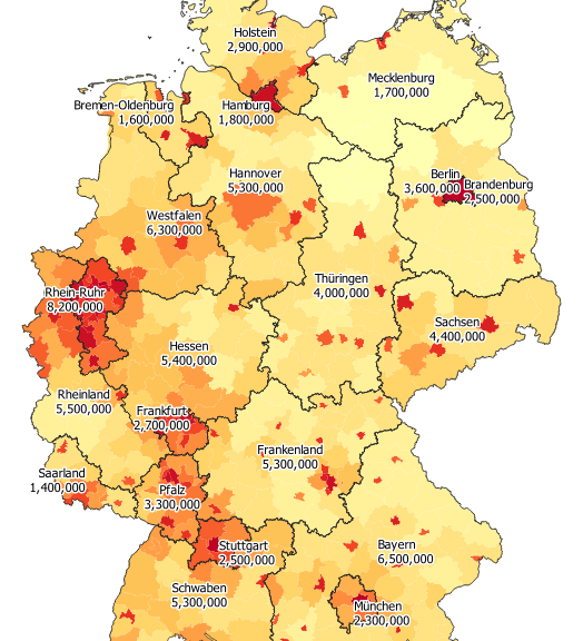
Germany
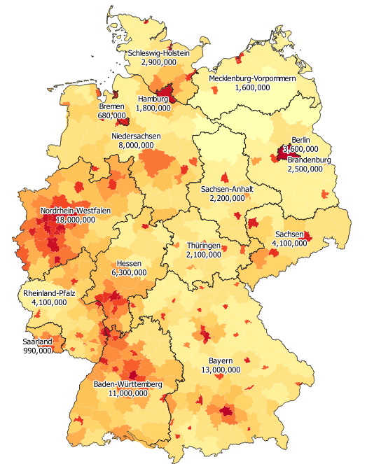
Germany is one of the easier countries to apply these rules to, as its Länder are already relatively close in size – Nordrhein-Westfalen has only 26 times the population of Bremen!
There isn’t the same issue that the US has with Alaska – none of the small Länder are quite so difficult to increase in size, so we can aim for a range of sizes that is slightly larger than the one proposed for the US above.
The smallest of the Länder is the “Free Hanseatic City of Bremen“. Merging it with a much larger more rural region would likely be unpopular, as it is currently a city-state and would lose a lot of autonomy under such a proposal. Thankfully it borders the historical “Duchy of Oldenburg” which contained the cities of Oldenburg, Delmenhorst and Wilhelmshaven. Combining Bremen with Oldenburg gives a region with a population of 1.6 million, at least 1 million of which live in the aforementioned cities, allowing it to retain a reasonably city-state like character.
The next smallest is Saarland, which also has a unique character given its history as a French protectorate. Merging it into a significantly larger region therefore would also be very unpopular. Extending Saarland slightly Northwards to include the city of Trier, and Eastwards to include the towns of Zweibrücken and Pirmasens gives a region with a population of 1.4 million, whilst hopefully still maintaining its character.
Taking this as the new smallest region gives us a largest permissable state of 11.2 million, which is large enough to not necessitate completely redrawing everything (unlike the US). In fact, to meet the size restrictions, we would only technically need to split Nordrhein-Westfalen and Bayern in two. Taking composition into account does push us towards making slightly more extensive changes than this though.
Firstly, aside from the existing city-states of Berlin, Hamburg and Bremen, there are several other large cities that could be split off into autonomous city-states in their own rights. These are:
- Frankfurt
- Stuttgart
- München
- The polycentric Rhein-Ruhr conurbation containing
- Dortmund
- Essen
- Duisburg
- Köln
- Bonn
By taking the area around each of Frankfurt, Stuttgart and München that includes most of their metropolitan area, we get three city-states of reasonable sizes – between 2.3 and 2.7 million people each. On the other hand, the entirety of the Rhein-Ruhr conurbation’s metropolitan area would cover most of Nordrhein-Westfalen, so taking only the core, densely populated districts is preferable in this case. This gives a city-state of 8.2 million people – large, but well within the permissable limits.
After carving out these cities, we need to tidy up the other borders – among other things, the Rhine-Ruhr conurbation has left Nordrhein-Wesfalen with a huge hole in it:
- The Western part of Nordrhein-Westfalen can be combined with Rheinland-Pfalz, the Eastern part with Hessen, and the Northern part with Niedersachsen
- Niedersachsen is then very large, so can be split West-East into Westfalen and Hannover
- Rheinland-Pfalz is also quite large, so can be split into Rheinland to the North-West and Pfalz to the South-East
- Pfalz can be extended into Baden-Württemberg, to include Mannheim, Heidelburg and Karlsruhe, forming a moderately densely populated region of many small cities (covering a similar area to the old Bavarian district of Rheinkreis)
- Bayern is still too large, so its Northern districts of Oberfranken, Mittelfranken and Unterfranken can be split off to form Frankenland (along with the bit of Baden-Württemberg to the North-East of Stuttgart)
- Thüringen and Sachsen-Anhalt are quite demographically similar and relatively small, so can be combined, along with a few other minor border changes
These adjustments result in the following map:
We have increased the number of Länder from 16 to 21, but now Rhein-Ruhr (the largest) is only 5.9 times the size of Saarland (the smallest), and there are between 6 and 8 city-states, depending on how you classify Bremen-Oldenburg and Pfalz.
| Name | Area (km²) | Population | Density |
|---|---|---|---|
| Berlin | 885 | 3,600,000 | 4038 |
| Hamburg | 768 | 1,800,000 | 2357 |
| Rhein-Ruhr | 5,769 | 8,200,000 | 1429 |
| Frankfurt | 2,402 | 2,700,000 | 1107 |
| München | 2,468 | 2,300,000 | 936 |
| Stuttgart | 3,022 | 2,500,000 | 828 |
| Pfalz | 6,416 | 3,300,000 | 518 |
| Bremen-Oldenburg | 4,469 | 1,600,000 | 347 |
| Saarland | 4,946 | 1,400,000 | 288 |
| Rheinland | 19,964 | 5,500,000 | 278 |
| Westfalen | 26,030 | 6,300,000 | 242 |
| Schwaben | 23,538 | 5,300,000 | 226 |
| Sachsen | 20,004 | 4,400,000 | 218 |
| Hessen | 26,274 | 5,400,000 | 206 |
| Holstein | 15,652 | 2,900,000 | 184 |
| Frankenland | 29,511 | 5,300,000 | 178 |
| Hannover | 32,198 | 5,300,000 | 165 |
| Bayern | 45,024 | 6,500,000 | 144 |
| Thüringen | 33,754 | 4,000,000 | 118 |
| Brandenburg | 28,836 | 2,500,000 | 88 |
| Mecklenburg | 25,334 | 1,700,000 | 67 |
Also, in case is wasn’t already obvious, I am a big fan of self determination. I fully support the residents of each region being able to vote on what they call themselves, so if you don’t like the names here, feel free to change them!
Canada
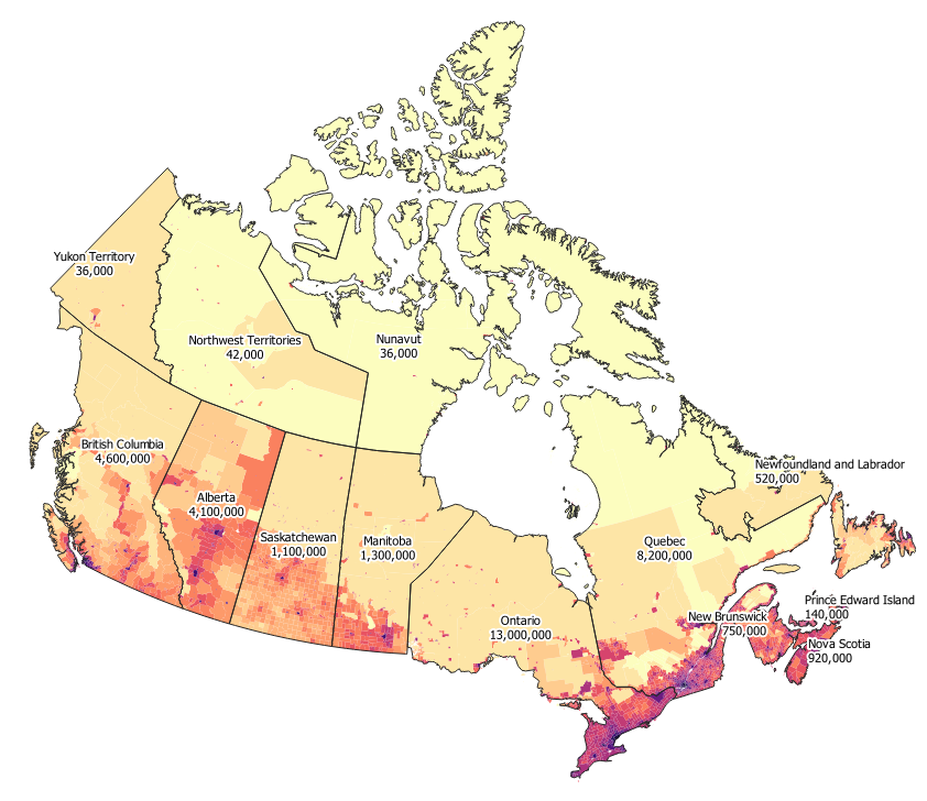
Canada is on the other end of the scale – including its territories as well as its provinces, Ontario has over 360 times the population of Nunavut.
On the one hand, if we took Nunavut and Yukon Territory to be the minimum permissible province size, the maximum at 8 times this would be a population of only 288,000 which would require Canada to be split into in excess of 130 different states.
On the other hand, autonomy for Nunavut was a long awaited development, and was largely welcomed by the Inuit community. To reduce its autonomy by combining it with other areas would likely be an unpopular move.
Thankfully, the idea of semi-autonomous subdivisions is probably helpful here. Currently, the provinces are considered sovereign whilst the territories only have delegated authority from the federal government. If done correctly, the creation of a new province would not have to diminish the autonomy of any current territory – shifting powers from the federal government to the new provincial government without shifting powers from the subdivisions to the provincial government. This would allow the former territories the same level of autonomy as before (presumably greater autonomy than subdivisions of other provinces), whilst providing the federal government a larger entity to interact with.
Even with this, it seems likely that the sparsely populated North will be the province with the lowest population and will therefore constrain the maximum permissible provincial population. This then raises the question of how high we can get the population of this Northern province whilst adhering to the idea that it should have a relatively consistent character, maintaining its property of having a very low population density so that it doesn’t have to deal with the needs of any sizeable cities.
As it happens, the Northernmost parts of British Columbia, Alberta, Saskatchewan and Manitoba are very sparsely populated, and would not be out of place in such a province. Nord-du-Québec and Labrador also have a very low population density in general, and a significant Inuit population in the areas of Kativik and Nunatsiavut respectively.
To make it easier to discuss, I am going to refer to this province as Borealia (after all, it does contain a large amount of the boreal forest). As with Germany, any names mentioned here should be considered placeholders. We can finesse the borders of the province later, but for now, to give an idea of the population size that we can easily achieve, let’s add up the populations of all of these territories and districts:
| Territory/District | Population |
|---|---|
| Nunavut | 35,944 |
| Yukon | 35,874 |
| Northwest Territories | 41,786 |
| Nord-du-Quebec | 44,561 |
| Labrador | 27,197 |
| Division 21, Manitoba | 21,606 |
| Division 22, Manitoba | 38,421 |
| Division 23, Manitoba | 8,252 |
| Division 18, Saskatchewan | 37,064 |
| Mackenzie County, Alberta | 11,171 |
| Northern Rockies, BC | 5,393 |
| Stikine Region, BC | 740 |
| Total | 308,009 |
With a combined population of 308,000 we can call this our minimum province size, which limits our maximum size to 2.46 million.
We will come back to this Borealia later, and deal with the question of subdivisions, but first let’s try to work within the above constraints, and see what provinces are possible.
Firstly, there are 5 cities in canada with a population over 1 million, making them easily large enough to be provinces in their own rights:
- Toronto
- Montreal
- Vancouver
- Calgary
- Edmonton
Calgary and Edmonton are both surrounded by a few smaller population centres, which make the areas around them slightly more densely populated than most of the rest of Alberta. If these regions are carved out into their own provinces (each with around 1.5 million people), this almost splits Alberta into two, making it reasonable to divide the remaining area of Alberta into a North-Westerly province (I will refer to this as Jasper, as it contains Jasper National Park) and a South-Easterly one (Alberta), each of which contains around 500,000 people – well within the size constraints.
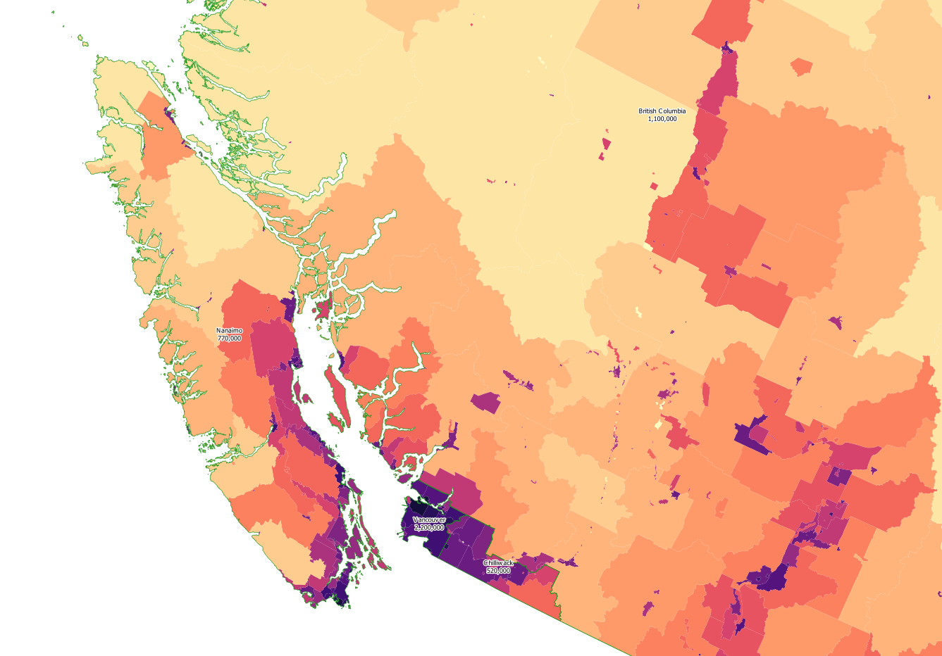
Vancouver is a significantly larger city, so its metropolitan area can be split from British Columbia forming a densely populated province of over 2 million people. To its East is a commuter corridor sandwiched between the Fraser river and the border with the US, which can also be split from the rest of BC forming another state of around 500,000 people (Chilliwack). Another very straight-forward division would be to make Vancouver Island its own province of around three-quarters of a million people (Nanaimo), leaving the rest of British Columbia with just over 1 million.
Moving further East, having already transferred the very sparsely populated Northern districts of Saskatchewan and Manitoba to Borealia, they both have a fairly even population density, and populations slightly over 1 million, so need no further adjustment. The next province we reach is Ontario, but from Kenora all the way to Algonquin Provincial Park is exceedingly sparsely populated, making it sensible to carve off Northern Ontario into another province of around three-quarters of a million people (Huron).
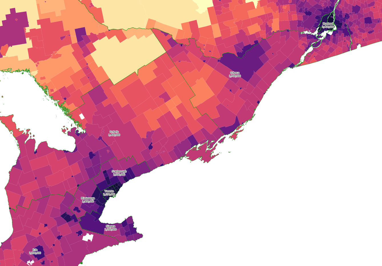
Southern Ontario is still far too large at almost 13 million people, and whilst we might intend to split Toronto into a separate province, even the core of the City of Toronto clocks in at 2.7 million people which is slightly too large. Excluding the district of Scarborough to the East leaves Toronto with 2.1 million people, then the remainder of the Golden Horseshoe can be split into 3 provinces – Scarborough to the North and East of Toronto, Mississauga to the West and Niagara to the South (across Lake Ontario).
Chopping the Golden Horseshoe out of Southern Ontario removes its most densely populated areas, but still leaves over 5 million people in the region, meaning that it will need to be split into at least 3 provinces to come within the population thresholds. From West to East, I shall refer to these as Erie, Ontario and Ottawa.
The Francophone province of Quebec is up next, with a population of over 8 million (even after having removed the district of Nord-du-Quebec, which makes up over 50% of its area). As mentioned above, Montreal can be made into its own province, and as it is on an island, the most natural boundary for this province is the river splitting the islands of Montreal and Laval from the rest of Quebec. This gives the province of Montreal a population of 2.4 million – just under the threshold.
The St. Lawrence River divides Quebec into a North and a South, with the South being significantly more densely and more uniformly populated. It therefore makes sense to split this Southern region off to form its own province (Appalaches). The remaining Northern part of Quebec is still too large to be a single province, so can be split into an East and a West province. The West province (Laurentides) consists of the valleys directly North of Montreal – a tourist destination known for outdoors pursuits, while the East province (Quebec) contains Quebec City itself along with Saguenay and the coastline of the Gulf of St. Lawrence. This results in 4 Francophone provinces, meaning that the lone French voice in the Council of the Federation will no longer be alone.
Finally we reach the Atlantic Provinces. New Brunswick is the only province that is officially bilingual English and French – two thirds of its population of three-quarters of a million people speak English, while one third speak French. As it happens though, the new province of Appalaches is slightly too large, and the Gaspé peninsula along with the Southern shore of the St. Lawrence Estuary that border New Brunswick are significantly less densely populated than the rest of the province. Moving this region from Appalaches to New Brunswick reduces the population of Appalaches to 2.3 million whilst increasing New Brunswick’s to just over 1 million, making the proportion of French speakers in New Brunswick close to 50%.
Prince Edward Island is a very small province that is below the minimum threshold, so it can be combined with Nova Scotia (which has a similar population density). If they are to be part of the same province, it might also be sensible to shift the border between Nova Scotia and New Brunswick slightly to the West, so that the Confederation Bridge is part of Nova Scotia too. This increases Nova Scotia’s population to just over 1 million.
With Labrador moved to be a part of Borealia, Newfoundland is now on its own. Having a population of just under 500,000 places it well within the tolerances, so it can quite happily be its own province. Furthermore, as a populous island, it makes sense for Newfoundland to have autonomy rather than be ruled from a capital a boat-ride away, similar to Vancouver Island/Nanaimo.
This is mostly it, aside from a few minor border adjustments. As the Western border of the former Alberta, Jasper’s Western border follows the limit of the Nelson River drainage basin followed by the Mackenzie River drainage basin until it hits the line of longitude 120° West. Instead of going directly North at this point, Jasper could be extended further Westwards, continuing to use the Mackenzie River drainage basin as its border until it meets with Borealia.
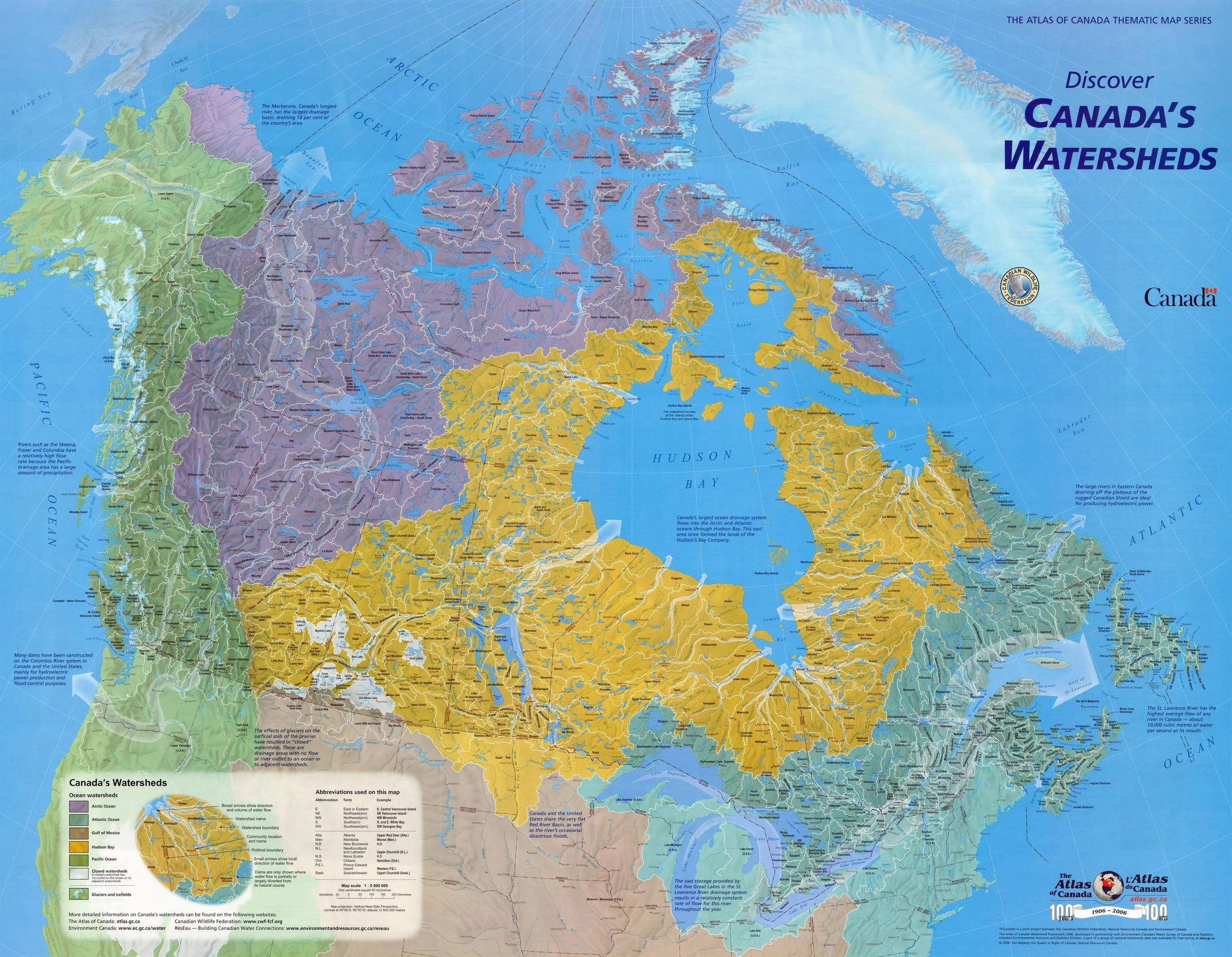
In a similar vein, Borealia’s Southern border would be a fairly messy affair if it used the borders of the districts given in the table above. Instead, watersheds can be used, giving a more pleasing borderline.
Borealia does not yet include any of Northern Ontario (now Huron), despite incorporating parts of Manitoba and Quebec on either side. Even relative to Huron’s low population density, the Northern areas are extremely remote and sparsely populated, making them a more natural fit with the rest of Borealia than with the rural but accessible Southern part of Huron, which includes Thunder Bay, Timmins and Sudbury. Kenora District and Cochrane District both extend too far South to be able to move them into Borealia in their entirety, but using a combination of watersheds and the census boundaries of settlements on the ON-11 highway, a large area with a tiny population can be carved out of Huron. This allows us to increase the population of Borealia slightly, making Montreal less close to the upper threshold of 8 times the smallest province.
The proposed province of Ottawa has similar borders to the region of Eastern Ontario, which has a Francophone population of around 270,000. As well as having a large Francophone presence, it contains the federal capital of Ottawa, so making it another province with both English and French as official languages is hopefully not an unreasonable concept. The Regional County Municipality of Vaudreuil-Soulanges is separated from the rest of Quebec by the St Lawrence River and the Ottawa River, but it shares a land border with the new province of Ottawa. By incorporating this municipality into a bilingual Ottawa instead, it would add another 100,000 French speakers, making the province of Ottawa over 20% Francophone, as well as yielding a more natural boundary between the provinces.
With this, we can see the final 26 provinces that have been laid out. They are shown below, overlaid onto the same population density map as before:
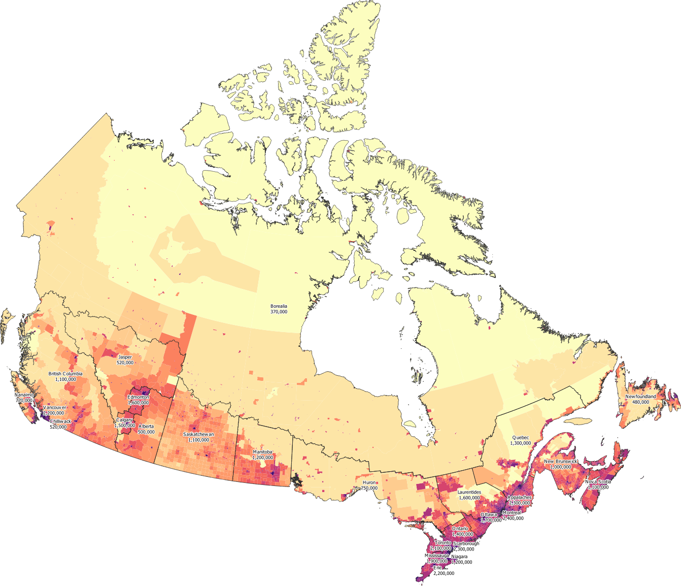
Even zoomed in, several of the states are a little on the small side, so here are some close-ups:
As per the table below, you can see that the most populous province (Montreal) has 6.5 times the population of the least (Borealia). In terms of area though, Borealia is over 15,000 times the size of Toronto.
| Province | Area (km²) | Population | Density |
|---|---|---|---|
| Toronto | 446 | 2,100,000 | 4,717 |
| Montreal | 789 | 2,400,000 | 3,046 |
| Vancouver | 1,422 | 2,200,000 | 1,521 |
| Mississauga | 2,944 | 1,900,000 | 649 |
| Scarborough | 3,812 | 2,300,000 | 610 |
| Niagara | 3,220 | 1,200,000 | 363 |
| Chilliwack | 2,792 | 520,000 | 187 |
| Erie | 25,243 | 2,200,000 | 87.9 |
| Calgary | 20,440 | 1,500,000 | 74.3 |
| Ottawa | 25,492 | 1,700,000 | 65.2 |
| Edmonton | 24,780 | 1,600,000 | 63.3 |
| Appalaches | 43,099 | 2,300,000 | 54.2 |
| Ontario | 50,799 | 1,400,000 | 27.4 |
| Nanaimo | 33,481 | 770,000 | 22.9 |
| Nova Scotia | 62,024 | 1,100,000 | 17.2 |
| Laurentides | 137,462 | 1,600,000 | 11.9 |
| New Brunswick | 123,790 | 1,000,000 | 8.25 |
| Manitoba | 209,314 | 1,200,000 | 5.77 |
| Quebec | 302,807 | 1,300,000 | 4.42 |
| Newfoundland | 111,239 | 480,000 | 4.32 |
| Alberta | 137,294 | 500,000 | 3.65 |
| Saskatchewan | 344,246 | 1,100,000 | 3.08 |
| British Columbia | 524,199 | 1,100,000 | 2.06 |
| Huron | 399,871 | 750,000 | 1.87 |
| Jasper | 411,119 | 520,000 | 1.27 |
| Borealia | 6,873,478 | 370,000 | 0.053 |
Borealia
As mentioned earlier, it is worth looking more closely at Borealia, as the existing territories are very likely to want significant autonomy within the province itself. This proposal therefore needs to incorporate details of Borealia’s semi-autonomous subdivisions in order to avoid giving the impression that the territories would be completely subsumed and might lose their existing autonomy.
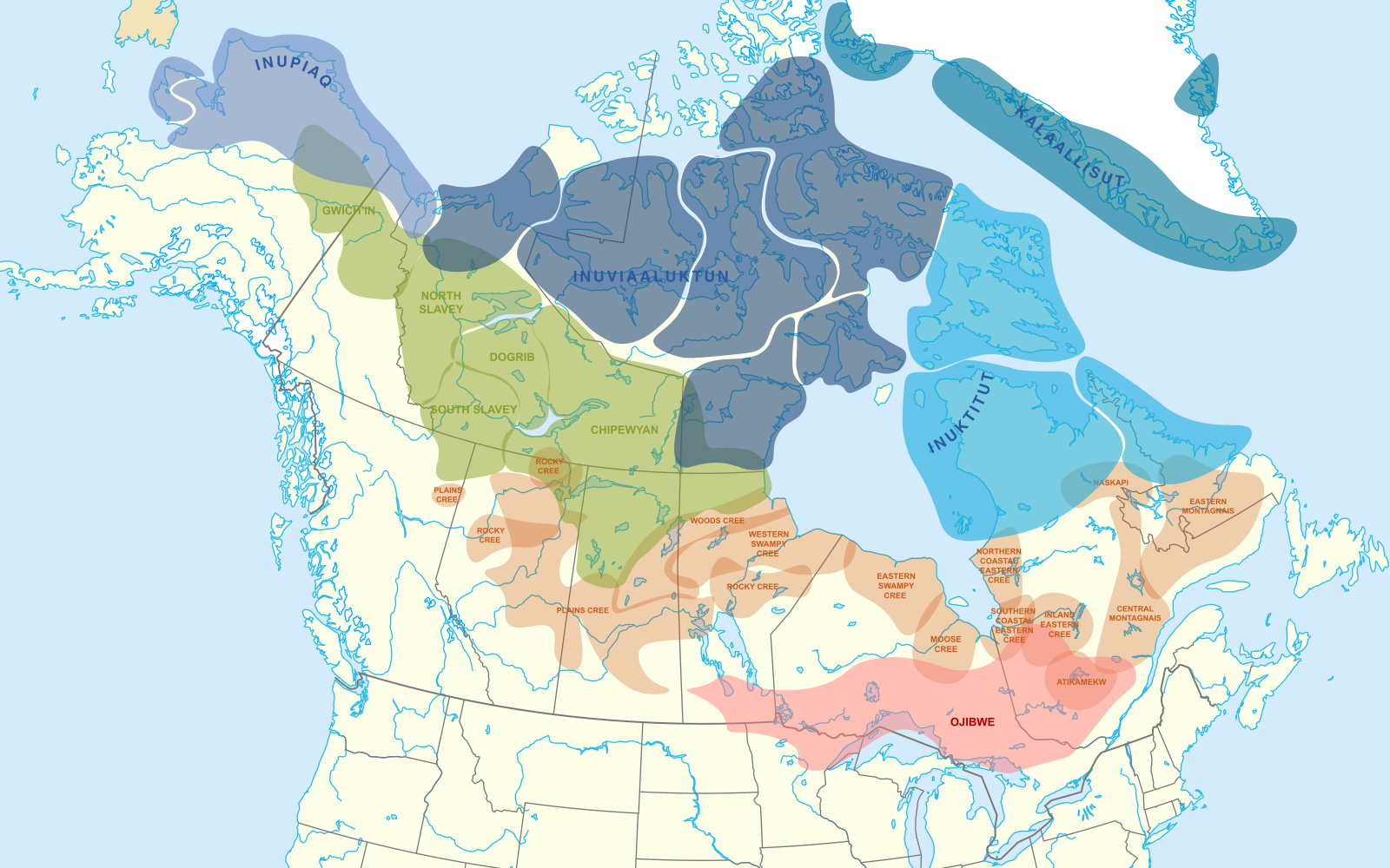
There are four groups of indigenous languages present in the area covered by Borealia:
- The Cree dialect continuum (orange), which has 117,000 speakers
- The Ojibwe dialect continuum (red), which has 56,000 speakers, 48,000 of whom are in Canada
- The Inuit dialect continuum (blue), of which Inuktitut is the most prevalent dialect in Canada with around 40,000 speakers
- The Athabascan languages (green), of which Dënësųłinë́ (also known as Chipewyan) is by far the most prevalent with around 12,000 speakers, followed by Slavey (2,100 speakers), Tłı̨chǫ Yatıì (also known as Dogrib, 1,700 speakers) and Gwich’in (500 speakers)
It is apparent that Ojibwe is mostly too far south to be relevant, with most speakers residing in Huron and Laurentides. Also there is little presence of indigenous languages in most of Yukon Territory. This suggests that the four language groups of Cree, Inuit, Athabascan languages and English could be used to define districts.
This aligns with the motivation behind Nunavut becoming its own territory, allowing the Inuit communities a greater degree of self-determination. Currently the Northwest Territories have 11 official languages however, which include 3 Inuit dialects as well as French and Cree. With so many languages each of which with so few speakers, this presents a risk that language resources may be spread too thinly, making preserving the languages more difficult.
By splitting Borealia more carefully along linguistic lines, it should be possible to create autonomous subdivisions that each have a smaller number of more dominant indigenous languages, allowing greater focus on preserving both language and culture. Using watersheds, I have divided Borealia into 5 districts:
- Yukon – largely English speaking with little indigenous language presence – Yukon River basin and Northern BC
- Nunavut – all Inuit communities including Northern Quebec and Labrador – Arctic drainage basin
- Athabasca – largely English speaking but with significant Athabascan language communities – most of the Mackenzie River basin
- Algonquia – Cree communities in Saskatchewan, Manitoba and Ontario
- Labrador – Cree communities East of James Bay – separated from Algonquia to avoid a long, thin district that would be difficult to administer
The map below shows all of the settlements in Borealia with more than 1,000 residents. Nearby settlements that are separate for census purposes are counted together:
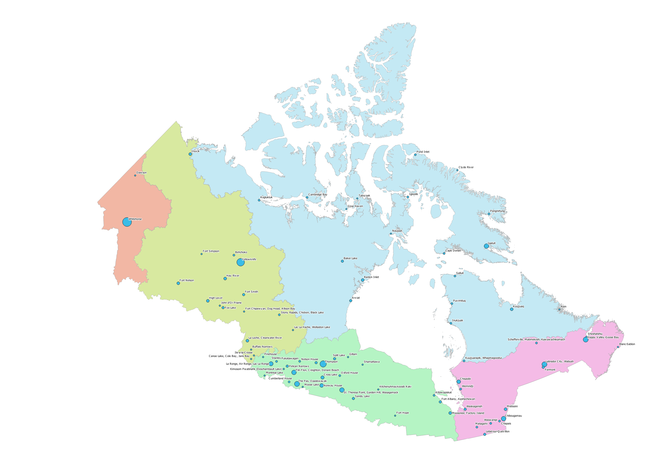
| Division | Map Colour | Area (km²) | Population | Density |
|---|---|---|---|---|
| Algonquia | Green | 885,269 | 120,148 | 0.1357 |
| Labrador | Purple | 673,897 | 62,709 | 0.0931 |
| Yukon | Red | 381,184 | 35,287 | 0.0926 |
| Athabasca | Yellow | 1,631,991 | 91,953 | 0.0563 |
| Nunavut | Blue | 3,301,137 | 55,730 | 0.0169 |
The 80 settlements shown on this map account for about 250,000 of the total 370,000 people in Borealia, meaning that one third of the population of Borealia live in remote settlements of less than 1,000 people. Of these 250,000 people, about half live in the largest 13 settlements:
| Settlement | Subdivision | Population |
|---|---|---|
| Whitehorse | Yukon | 25,085 |
| Yellowknife | Athabasca | 19,569 |
| Thompson | Algonquia | 13,678 |
| Labrador City, Wabush | Labrador | 9,126 |
| The Pas, Opaskwayak | Algonquia | 8,403 |
| Happy Valley-Goose Bay | Labrador | 8,109 |
| Iqaluit | Nunavut | 7,740 |
| Chibougamau | Labrador | 7,504 |
| Flin Flon, Creighton, Denare Beach | Algonquia | 7,366 |
| St. Theresa Point, Garden Hill, Wasagamack | Algonquia | 7,264 |
| La Ronge, Air Ronge, Lac La Ronge | Algonquia | 6,416 |
| Norway House | Algonquia | 4,927 |
| Chisasibi | Labrador | 4,872 |
Final Proposal
To better see the borders of the 26 provinces (and the 5 semi-autonomous subdivisions), I have again produced a zoomable overlay on Googlemaps: